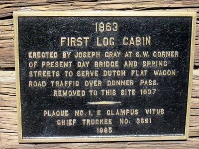
First Log Cabin
Erected by Joseph Gray at S.W. corner of present day Bridge and Spring Streets to serve Dutch Flat Wagon Road traffic over Donner Pass.
Removed to this site 1907
Plaque NO. 1, E Clampus Vitus
Chief Truckee No. 3691
1965
Location. 39° 19.743′ N, 120° 11.027′ W. Marker is in Truckee, California, in Nevada County. Marker is on Church Street east of Bridge Street, on the right when traveling west. Touch for map. Marker is at or near this postal address: 10030 Church Street, Truckee CA 96161, United States of America.
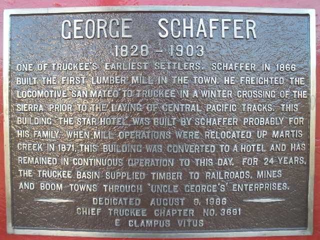
George Schaffer
One of Truckee’s earliest settlers, Schaffer in 1866, built the first lumber mill in town. He freighted the locomotive San Mateo to Truckee in a winter crossing of the Sierra prior to the laying of the Central Pacific Tracks. This building the “Star Hotel” was built by Schaffer probably for his family, when mill operations were relocated up Martis Creek in 1871. This building was converted to a hotel and has remained in continuous operation to this day, for 24 years. The Truckee basin provided timber to railroads, mines and boom towns through Uncle George’s enterprise.
Dedicated August 9, 1986
Chief Truckee Chapter 3691
E Clampus Vitus
N 39° 19.627 W 120° 11.037
10S E 742739 N 4356860
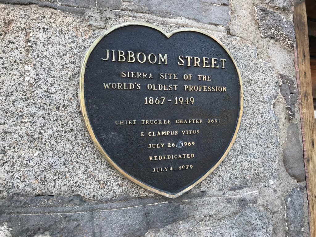
Jibboom Street
Sierra site of the world’s oldest profession 1867-1949
Chief Truckee Chapter 3691 E Clampus Vitus
July 26, 1969
Rededicated July 4, 1979
N 39° 19.748 W 120° 11.076
10S E 742676 N 4357081
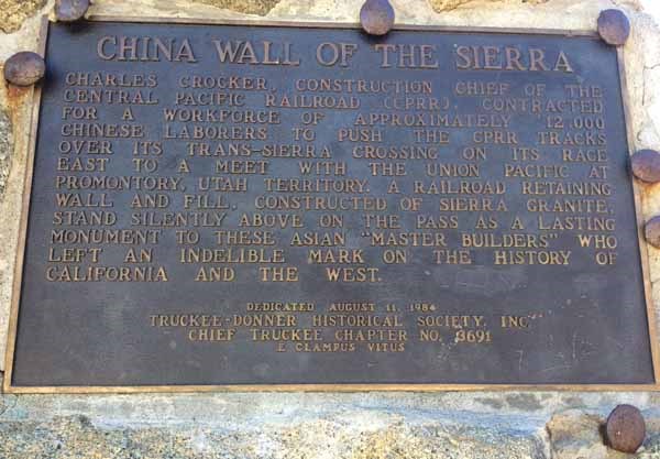
China Wall of the Sierra — Donner Pass, CA
CHINA WALL OF THE SIERRA
CHARLES CROCKER, CONSTRUCTION CHIEF OF THE CENTRAL PACIFIC RAILROAD (CPRR), CONTRACTED FOR A WORKFORCE OF APPROXIMATELY 12,000 CHINESE LABORERS TO PUSH CPRR TRACKS OVER ITS TRANS-SIERRA CROSSING ON ITS RACE EAST TO A MEET WITH THE UNION PACIFIC AT PROMONTORY, UTAH TERRITORY. A RAILROAD RETAINING WALL AND FILL, CONSTRUCTED OF SIERRA GRANITE, STANDS SILENTLY ABOVE ON THE PASS AS A LASTING MONUMENT TO THESE ASIAN “MASTER BUILDERS” WHO LEFT AN INDELIBLE MARK ON THE HISTORY OF CALIFORNIA AND THE WEST.
DEDICATED AUGUST 11, 1984
TRUCKEE-DONNER HISTORICAL SOCIETY, INC.
CHIEF TRUCKEE CHAPTER NO.. 3691
E CLAMPUS VITUS
N 39° 19.016 W 120° 19.165
10S E 731094 N 4355374
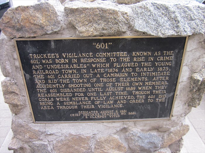
601 – Truckee, CA
Truckee’s vigilance committee, known as the 601 was born in response to the rise of crime and undesirables that plagued the young railroad town. In the late 1874 and early 1875, the 601 carried out a campaign to intimidate and rid the town of those elements. After accidentally shooting one of their own members, the 601 disbanded until August 1889 when they reassembled for one last time. Though their goals were never fully achieved, the 601 did bring a semblance of law and order to the area through their vigilance.
Dedicated August 6, 1981
Chief Truckee Chapter 3691
E Clampus Vitus
N 39° 19.674 W 120° 11.124
10S E 742611 N 4356943
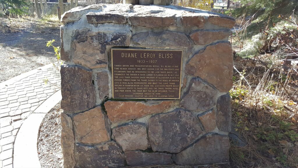
DUANE LEROY BLISS
1833-1907
TIMBER BARON AND TRANSPORTATION MOGUL, D. L. BLISS – A ONE TIME NEVADA BANKER- WAS BEST KNOWN FOR THE RAILROADS AND STEAMSHIPS THAT HE INTRODUCED TO THE LAKE TAHOE BASIN. HE ORGANIZED THE CARSON & TAHOE LUMBER & FLUMING CO. IN 1871 AND THE LAKE TAHOE NARROW GAUGE RAILROAD AT GLENBROOK IN 1875 TO PROVIDE TIMBER FROM THE TAHOE SHORES TO THE MINES OF VIRGINIA CITY. IN 1898, BLISS REORGANIZED AND BUILT THE LAKE TAHOE RAILWAY & TRANPROTATION CO. FROM THE SOUTHERN PACIFIC DEPOT IN TRUCKEE SOUTH TO TAHOE CITY AND THE TAHOE TAVERN HOTEL AND PIER WHERE THE TRAIN MET THE BLISS STEAMER, “TAHOE.”
This marker was dedicated August 13, 1983 by the
Chief Truckee Chapter No.3691 E Clampus Vitus
N 39° 09.997 W 120° 08.605
10S E 746796 N 4339153
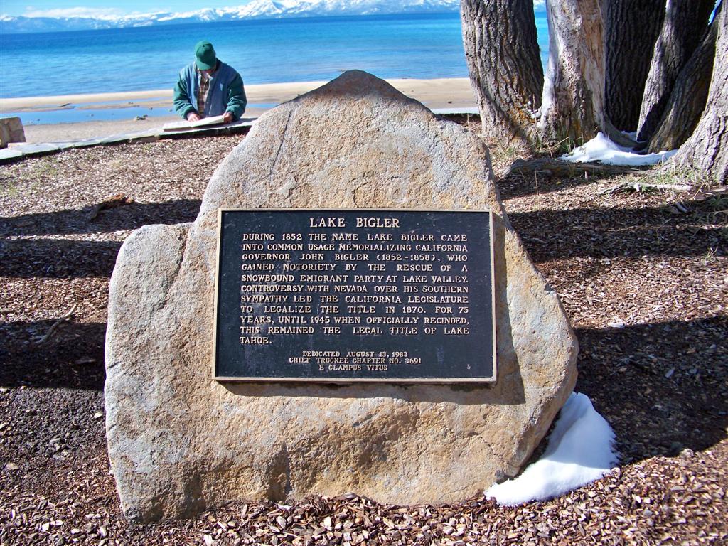
LAKE BIGLER – Kings Beach, California
Lake Bigler
During 1852 the name Lake Bigler came into common usage memorializing California governor John Bigler (1852-1858), who gained notoriety by the rescue of a snowbound emigrant party at Lake Valley. Controversy with Nevada over his Southern Sympathy led the California legislature to legalize the title in 1870. For 75 years, until 1945 when officially rescinded this remained the legal title of lake Tahoe.
Dedicated August 13, 1983
Chief Truckee Chapter No. 3691
E Clampus Vitus
N 39° 14.171 W 120° 01.483
10S E 756799 N 4347206
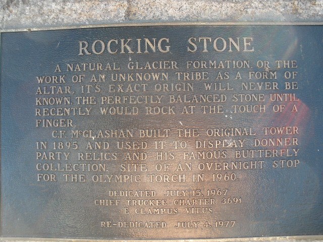
Rocking Stone – Truckee, CA
Just up the hill from downtown Truckee, this marker is situated in a gazebo, next to the Truckee Recreation and Parks Department building. The bronze plaque is attached to a large rock, or more appropriately, a Rocking Stone. The plaque on the stone reads:
“ROCKING STONE
A NATURAL GLACIER FORMATION OR THE WORK OF AN UNKNOWN TRIBE AS A FORM OF ALTAR, IT’S EXACT ORIGIN WILL NEVER BE KNOWN. THE PERFECTLY BALANCED STONE UNTIL RECENTLY WOULD ROCK AT THE TOUCH OF A FINGER.
C.F. McGLASHAN BUILT THE ORIGINAL TOWER IN 1895 AND USED IT TO DISPLAY DONNER PARTY RELICS AND HIS FAMOUS BUTTERFLY COLLECTION. SITE OF AN OVERNIGHT STOP FOR THE OLYMPIC TORCH IN 1960.
DEDICATED JULY 15, 1967
CHIEF TRUCKEE CHAPTER 3691
E CLAMPUS VITUS
RE-DEDICATED JULY 4, 1977
N 39° 19.682 W 120° 11.312
10S E 742341 N 4356949
From the Historic Truckee Walking Tour Brochure:
Rocking Stone Tower:
First Log Cabin
Legend tells us that this rock was used by Native Americans who inhabited this area to keep their fish and dried meat safe from animals and birds. The slightest vibrations of the smaller stone served to frighten the birds away and the height of the larger stone was too high for animals to climb. Although the stone no longer rocks, having been cemented in place, the 17-ton stone is one of 25 known rocking stones in the world.
Charles F. McGlashan, a prominent Truckee citizen from 1872 to 1931 and the man who interviewed the survivors of the Donner Party and wrote The History of the Donner Party, built an enclosed, high-arched windowed tower over this rock in 1893. Inside the tower he kept many of the Donner Party relics and memorabilia, which are now on display at the Donner Memorial State Park Museum. Here he also kept his exquisite collection of butterflies and moths, which can also be viewed at the Donner Museum.
Next to the rock, is the arched Veterans Memorial Building where McGlashan’s two-story residence once stood. Constructed in 1903, the residence was similar in design to the tower and when lit up at night, it was given the name, “McGlashan’s Crystal Palace.
In 1935 when the landmark was under the care of a caretaker, the mansion burned to the ground. For many years, the land stood vacant until, in 1939, members of the Truckee American Legion Post 439, under the auspices of James McIver Jr., constructed the present building which became a meeting place for most of the town’s community activities, including important town meetings, dances, parties, etc.
During World War II civil defense meetings were held in the hall. The nearby Rocking Stone Tower served as an aircraft observation post, as there was fear of an enemy attack on the railroad over the summit.
The building is presently owned by the Truckee-Donner Recreation and Park District and serves as a community center, as well as a meeting place for veterans and other community needs.”
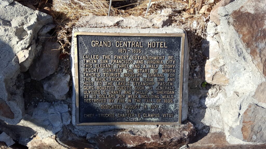
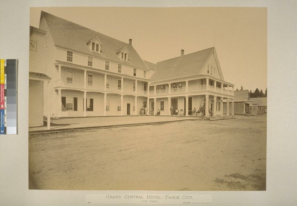
GRAND CENTRAL HOTEL
1871-1895
CALLED THE FINEST ESTABLISHMENT BETWEEN SAN FRANCISCO AND VIRGINA CITY, THIS ELEGANT THREE AND A HALF STORY RESORT SIGNIFIED THE START OF NORTH TAHOE’S TOURIST INDUSTRY. TERMINAL THE TAHOE-TRUCKEE FLYER STAGE LINE AND HOST TO THE LAKE’S STEAMSHIP PASSENGERS. BOASTED GUESTS SUCH AS GENERALS ULYSSES S. GRANT AND PHILLIP H. SHERIDAN AT 20 DOLLARS PER WEEK, INCLUDING MEALS. DESTROYED BY FIRE IN THE FALL OF 1895.
DEDICATED AUGUST 14, 1971
BY CHIEF TRUCKEE CHAPTER E CLAMPUS VITUS
C.P.R.R TRUCKEE ROUND HOUSE – Truckee, CA
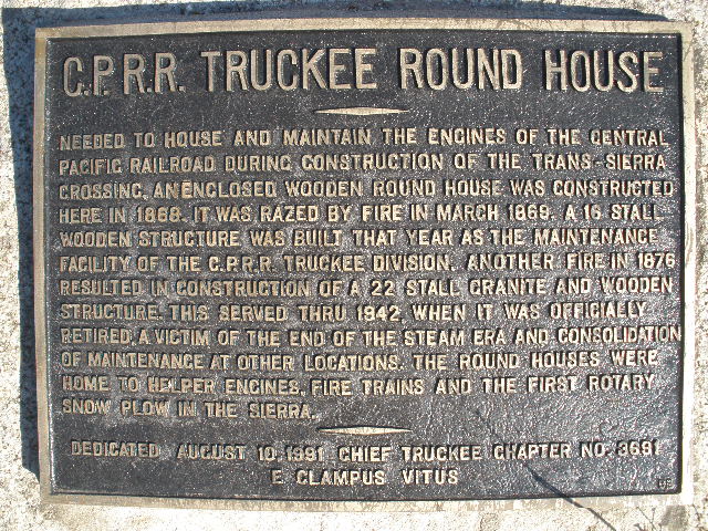
C.P.R.R TRUCKEE ROUND HOUSE
NEEDED TO HOUSE AND MAINTAIN THE ENGINES OF THE CENTRAL
PACIFIC RAILROAD DURING CONSTRUCTION OF THE TRANS-SIERRA
CROSSING, AN ENCLOSED WOODEN ROUND HOUSE WAS CONSTRUCTED
HERE IN 1868. IT WAS RAZED BY FIRE IN MARCH 1869. A 16 STALL
WOODEN STRUCTURE WAS BUILT THAT YEAR AS THE MAINTENANCE
FACILITY OF THE C.P.R.R. TRUCKEE DIVISION. ANOTHER FIRE IN 1876 RESULTED IN CONSTRUCTION OF A 22 STALL GRANITE AND WOODEN
STRUCTURE. THIS SERVED THRU 1942, WHEN IT WAS OFFICIALLY
RETIRED. A VICTIM OF THE END OF THE STEAM ERA AND CONSOLIDATION
OF MAINTENANCE AT OTHER LOCATIONS. THE ROUND HOUSES WERE
HOME TO HELPER ENGINES, FIRE TRAINS AND THE FIRST ROTARY
SNOW PLOW IN THE SIERRA.
DEDICATED AUGUST 10, 1991 CHIEF TRUCKEE CHAPTER NO. 3691
E CLAMPUS VITUS
N 39° 19.731 W 120° 10.949
10S E 742860 N 4357056
This historical marker is attached to a large boulder on the south side of the Lincoln Highway, at the east end of the downtown area. It is situated amidst other boulders between a glass repair company and a downtown parking lot. Other than this historical marker, there is no indication of the historical significance of this site.
“Lawrence Kearney, a Truckee native, was engineer for Southern Pacific. This is the second of three articles he wrote for the Truckee-Donner Historical Society Quarterly Newsletter at age 91 in 1994-5.
This structure housed twenty four stalls or pits as they were called and a turntable to turn the locomotives to be parked in the different stalls. The man who designed and supervised the building of this roundhouse was George Washington Barnhart, who was hired by Mark Hopkins for this project. Mr. Hopkins was known as one of the Big Four who built the Central Pacific Railroad.
This roundhouse was unique in its design. It was built of granite stone, quarried in Rocklin, California and hauled on the railroad to Truckee. The roundhouse had pillars or posts in a ways from the walls with the turntable in the center so the roof was held up by steel rods and braces–or as an early day astrodome. It had to be very sturdy on account of the heavy snows or it would collapse. The railroad later had larger locomotives and the smoke stacks would not fit under the chimneys in the roof of the roundhouse so most of the time when the stacks would not fit under the chimneys the locomotives were backed into the stalls with the smoke stacks toward the center of the roundhouse. This cause the smoke from the locomotives to collect in the top of the roundhouse and as the years went by there was enough sulfur fumes in the smoke that when condensation formed on the cold rods and braces it formed an acid that finally ate them away until they were unsafe. The roundhouse was then condemned and torn down in the 1940s.
This roundhouse was built as fire proof as possible with very little wood. The decking on the turn table pit that turned with the turn table was wood and the roof or decking was wood. The outside on top was covered with sheet steel called galvanized iron so it could not catch on fire from sparks or coals landing on the roof. This metal roofing attracted enough heat from the inside of the roundhouse to cause the snow to slide off the roof. The floor of the roundhouse was blocks of granite set in mortar or what would be called cobble stones. In between each stall was a large stove that could burn cord wood or coal. When the temperature got cold the doors on the roundhouse were closed and fires started in these stoves to heat up the roundhouse to keep the water pipes on the locomotives from freezing and bursting.
The first roundhouse in Truckee was a wooden structure that an arsonist set on fire and burned on March 29, 1869. Two other buildings also burned, the Iron House and the Oil house. There were eleven locomotives in the roundhouse at the time and all but one (the Piute) were saved. At that time locomotives were known by names instead of numbers. A man by the name of D.J. Hickey was tried in Nevada City on arson for setting the fire. At the trial on March 2nd, 1870, the jury voted seven for conviction and five for acquittal. A second trial was held with the same results so the railroad gave up.” (visit link)
Another, more detailed story can be found at: (visit link)
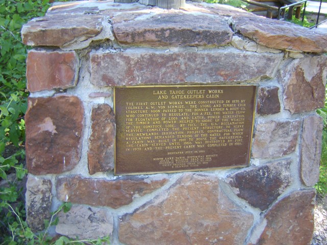
Lake Tahoe Outlet Works and Gatekeepers Cabin
THE FIRST OUTLET WORKS WERE CONSTRUCTED IN 1870 BY COLONEL A. W. VON SCHMIDT. THE STONE AND TIMBER CRIB STRUCTURE SOON PASSED TO THE DONNER LUMBER & BOOM CO. WHO CONTINUED TO REGULATE, FOR A FEE, THE WATER FLOW FOR FLOATATION OF LOGS AND LATER, POWER GENERATION. THE TIMBER AND POWER HELPED TO SHORE UP THE WEALTH OF THE COMSTOCK LODE. BY 1913, THE U.S. RECLAMATION SERVICE COMPLETED THE PRESENT STRUCTURE TO SERVE THE NEWLANDS IRRIGATION PROJECT. CONTRACTURAL FLOW REGULATIONS DEMANDED TENDING OF THE GATES FOR WHICH A CABIN WAS BUILT IN 1910 TO HOUSE THE GATEKEEPER. THE CABIN SERVED UNTIL 1968, WAS DESTROYED BY FIRE IN 1978 AND THE PRESENT CABIN WAS COMPLETED IN 1981.
The marker was dedicated July 19, 1981 by the North Lake Tahoe Historical Society, Julia C. Bulette Chap. No 1864, Snowshoe Thomson Chap. No 1827, and Chief Truckee Chap. No. 3691 E Clampus Vitus.
N 39° 09.997 W 120° 08.607
10S E 746793 N 4339153
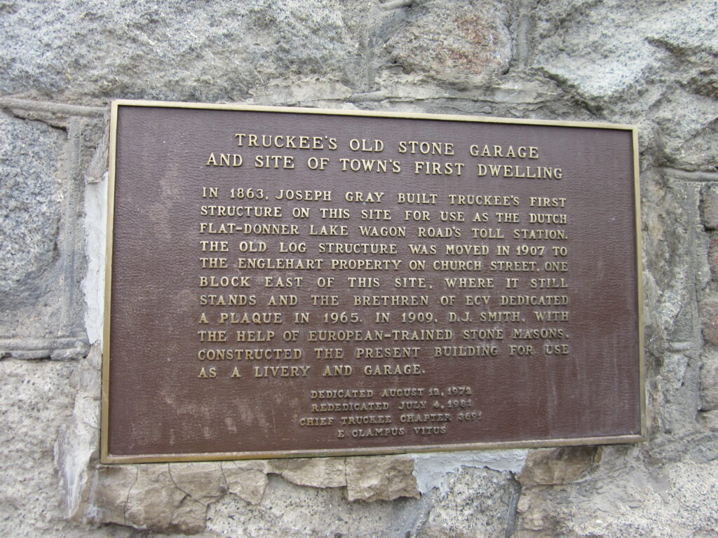
Truckee Old Stone Garage and site of town’s first dwelling – Truckee, CA
In 1863, Joseph Gray built Truckee’s first structure on this site for use as the Dutch Flat Donner Lake Wagon road’s toll station. The old log structure was moved in 1907 to the Englehart property of Church St, one block east of this site where it still stand and the brethren of ECV dedicated a plaque in 1965. In 1909, DJ Smith with the help of European trained stone masons constructed the present building for use as a livery and garage.
Dedicated August 12, 1973
Chief Truckee Chapter 3691
E Clampus Vitus
N 39° 19.743 W 120° 11.071
10S E 742683 N 4357073
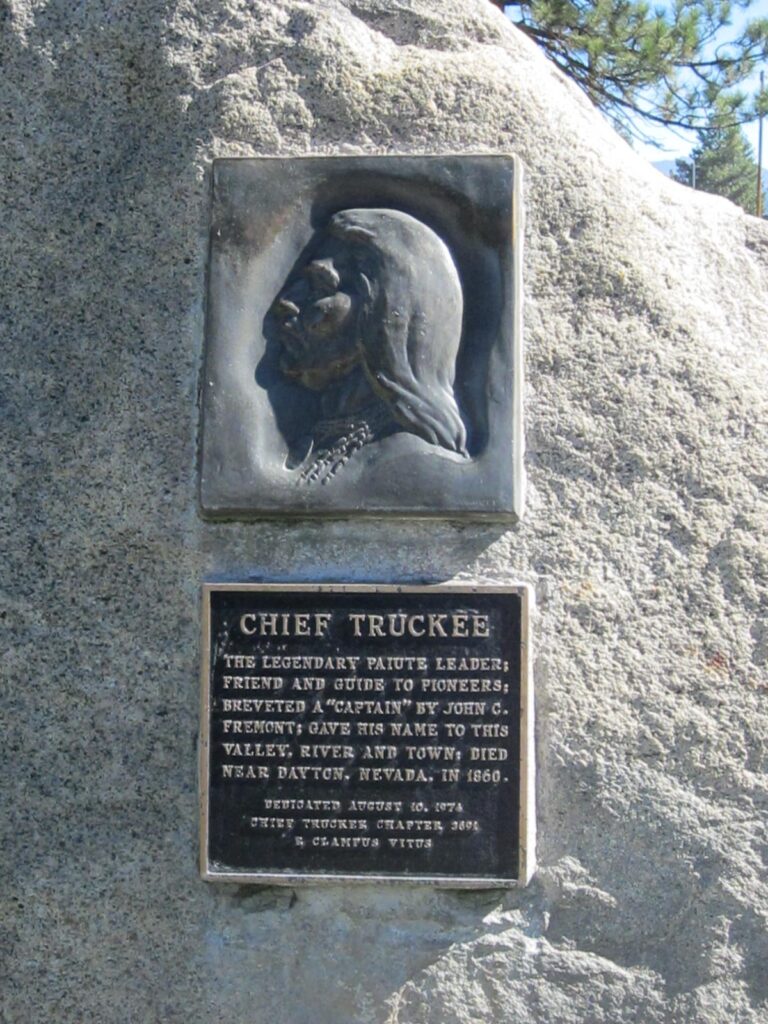
Chief Truckee
The legendary Paiute leader; friend and guide; breveted a “Captain” by John C. Fremont; gave his name to this valley, river and town: died near Dayton, Nevada, in 1860.
Dedicated August 10, 1974 by Chief Truckee Chapter 3691, E Clampus Vitus.
39° 19.607′ N, 120° 10.552′ W. Marker is in Truckee, California, in Nevada County. Marker can be reached from Brockway Road, on the left when traveling east. Marker is visible from the parking lot of the Truckee River Regional Park. Touch for map. Marker is at or near this postal address: 10870 Brockway Road, Truckee CA 96161, United States of America. Touch for directions.
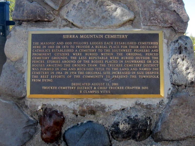
Sierra Mountain Cemetery
The Masonic and Odd Fellows Lodges each established cemeteries here in 1869 or 1870 to provide a burial place for their deceased. Catholics established a cemetery to the Southwest. Pioneers and prominent citizens within the original fenced cemetery grounds. The less reputable were buried outside the fences. Stories abound of the bodies placed in snowbanks or ice houses awaiting the ground thaw. The Truckee Cemetery District was formed in 1946 and received title to the land and named the cemetery in 1964. In 1954 the original site increased in size despite the best efforts of the community to prevent the townsfolk from dying.
Dedicated August 11, 2001
Truckee Cemetery District and & Chief Truckee Chapter 3691, E Clampus Vitus.
39° 20.043′ N, 120° 10.635′ W. Marker is in Truckee, California, in Nevada County. Marker can be reached from East Main Street. Marker is mounted at the entrance to the cemetery. Touch for map. Marker is in this post office area: Truckee CA 96161, United States of America. Touch for directions.
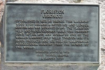
Floriston (Bronco)
Established in 1872 as Bronco, this railroad wood stop became a noted ice and lumber center and was renamed in 1891. The Floriston Pulp and Paper Company built the present town after 1899 and operated one of the world’s largest pulp mill through 1930. It paper products and ice helped California’s agricultural industry feed the hungry of the world.
Dedicated August 12, 1978 by E Clampus Vitus, Chief Truckee Chapter No. 3691.
39° 23.766′ N, 120° 1.344′ W. Marker is in Floriston, California, in Nevada County.
Marker is on Floriston Way near Interstate 80, on the right when traveling east. Floriston is at Interstate 80, exit 199. Touch for map. Marker is at or near this postal address: 10327 Floriston Way, Floriston CA 96111, United States of America. Touch for directions.
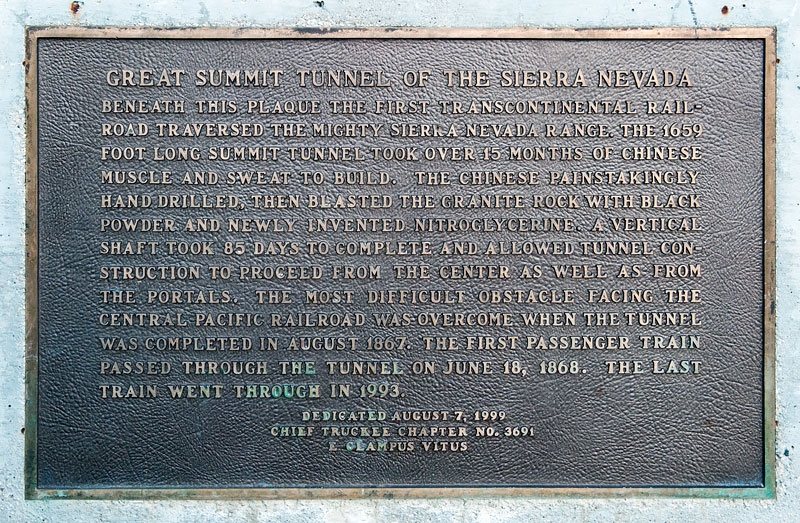
Great Summit Tunnel of the Sierra Nevada
Beneath this plaque the first transcontinental railroad traversed the mighty Sierra Nevada range. The 1659 foot long summit tunnel took over 15 months of Chinese muscle and sweat to build. The Chinese painstakingly hand drilled, then blasted the granite rock with black powder and newly invented nitroglycerin. A vertical shaft took 85 days to complete and allowed tunnel construction to proceed from the center as well as from the portals. The most difficult obstacle facing the Central Pacific Railroad was overcome when the tunnel was completed in August 1867. The first passenger train passed through the tunnel on June 18, 1868. The last train went through in 1993.
Dedicated August 7, 1999 by E Clampus Vitus, Chief Truckee Chapter No. 3691.
39° 18.984′ N, 120° 19.575′ W.
Marker is in Norden, California, in Nevada County. Marker can be reached from Old Donner Summit Road (Pacific Crest Trail) half a mile south of Donner Pass Road, on the right when traveling south. Marker is on the Pacific Crest Trail just south of Donner Pass Road at Donner Summit. Touch for map. Marker is in this post office area: Norden CA 95724, United States of America. Touch for directions.
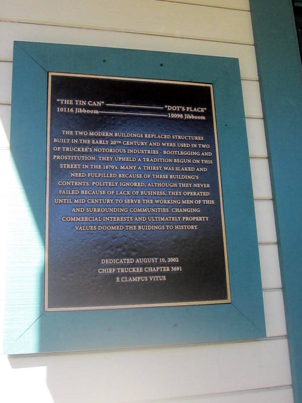
“The Tin Can” ———– “Dot’s Place”
10116 Jibboom –—————– 10098 Jibboom
The two modern buildings replaced structures built in the early 20th Century and were used in two of Truckee’s notorious industries • Bootlegging and prostitution. They upheld a tradition begun on this street in the 1870’s. Many a thirst was slaked and need fulfilled because of these building’s contents. Politely ignored, although they never failed because of lack of business, they operated until mid century to serve the working men of this and surrounding communities. Changing commercial interests and ultimately property values doomed the buildings to history.
Dedicated August 10, 2002 by Chief Truckee Chapter 3691, E Clampus Vitus.
Location. 39° 19.735′ N, 120° 11.107′ W. Marker is in Truckee, California, in Nevada County. Marker is on Jibboom Street, on the right when traveling west. The marker is mounted on the front of the building located at 10098 Jibboom Street.
The 10116 Jibboom site is where the smaller building on the left is seen and the 10098 Jibboom site is where the larger building on the right is located. The marker is mounted on the left front of the larger building.
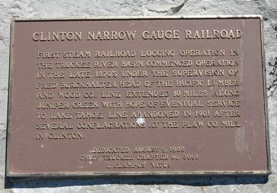
Clinton Narrow Gauge Railroad
First steam railroad logging operation in the Truckee River Basin. Commenced operation in the late 1870’s under the supervision of Fred Burckhalter, head of the Pacific Lumber and Wood Co. Line extended 10 miles along Juniper Creek with hopes of eventual service to Lake Tahoe. Line abandoned in 1901 after several configurations at the PL&W Co. mill in Clinton.
Dedicated August 9, 1980 by E Clampus Vitus, Chief Truckee Chapter No. 3691.
Location. 39° 22.086′ N, 120° 4.608′ W. Marker is near Truckee, California, in Nevada County. Marker is at the intersection of Hirschdale Road and Juniper Way, on the left when traveling south on Hirschdale Road.
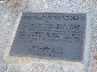
First Wagons Across the Sierras
The Stephens – Townsend – Murphy Party, with guidance from old Caleb Greenwood and Chief Truckee, brought their wagons up the Truckee River bed and on Nov. 25, 1844 191 days out of Council Bluffs, Iowa passed this point and crossed the mighty Sierra summit directly to the west, blazing the famous California Emigrant Trail for all who followed.
Dedicated August 14, 1976 by Chief Truckee Chapter 3691, E Camplus Vitus.
Location. 39° 19.38′ N, 120° 17.458′ W. Marker is in Truckee, California, in Nevada County. Marker is at the intersection of Donner Pass Road (Old Highway 40) and South Shore Drive, on the left when traveling west on Donner Pass Road. Marker is located at the west end of Donner Lake. Touch for map. Marker is at or near this postal address: 15963 South Shore Drive, Truckee CA 96161
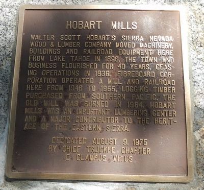
Hobart Mills
Walter Scott Hobart’s Sierra Nevada Wood & Lumber Company moved machinery, buildings and railroad equipment here from Lake Tahoe in 1896. The town and business flourished for 40 years. Ceasing operations in 1936. Fiberboard Corporation operated a mill and railroad here from 1946 to 1955, logging timber purchased from Southern Pacific. The old mill was burned in 1964. Hobart Mills was an important lumbering center and a major contributor to the heritage of the Eastern Sierra.
Dedicated August 9, 1975 by E Clampus Vitus, Chief Truckee Chapter #3691.
Location. 39° 23.881′ N, 120° 11.22′ W. Marker is near Truckee, California, in Nevada County. Marker is at the intersection of Hobart Mills Road and California Highway 89, on the right when traveling east on Hobart Mills Road.
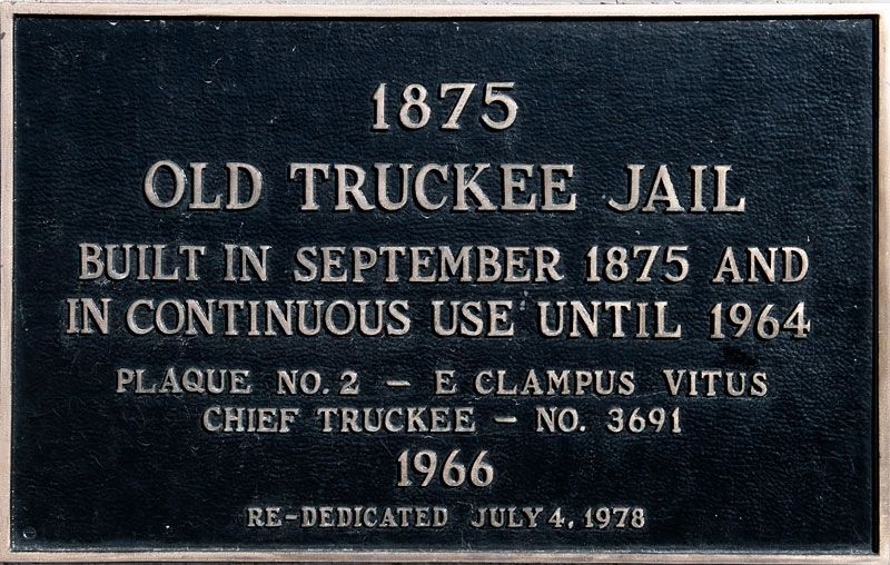
Old Truckee Jail
1875
Built in September 1875 and
in continuous use until 1964
Plaque No. 2 – E Clampus Vitus Chief Truckee No. 3691 1966
Re-Dedicated July 4, 1978
Location. 39° 19.68′ N, 120° 11.21′ W. Marker is in Truckee, California, in Nevada County. Marker is on 10142 Jibboom Street, on the left when traveling east.
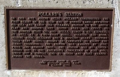
Pollard’s Station
On this site Joseph Delos Pollard constructed the first resort on the west end of Donner Lake. Between mid 1864 and early 1868 Pollard’s Station on the Dutch Flat and Donner Lake Wagon Road was office to the Pioneer Stage Co. and Wells, Fargo & Co. Express, as well as a two-story hotel, boasting bar room, reading room, billiards and a bowling alley. Visitors could rent boats, horses and carriages to enjoy the scenic grandeur. The station was ravaged by fire twice and rebuilt once. The station was no longer needed due to the railroad’s completion in June 1868, which put a virtual end to wagon and stage traffic across the Sierra.
Dedicated August 12, 2000 Chief Truckee Chapter No. 3691, E Clampus Vitus.
Location. 39° 19.344′ N, 120° 17.458′ W. Marker is in Truckee, California, in Nevada County. Marker is at the intersection of South Shore Drive and Old Highway Drive, on the right when traveling south on South Shore Drive.
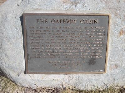
The Gateway Cabin
This cabin was one of several built by Jack Wolert for Dick Joseph in 1939 on US Route 40. The cabin was constructed of lumber salvaged from houses being dismantled 3 miles north of Truckee at Hobart Mills and served as the Gateway Motel’s Office. Originally located at the site of the current Gateway Shopping Center on Donner Pass Road (Historic US 40). It was donated to the Truckee Donner Historical Society in 1990 and moved to this location on May 11, 1991. Thanks to community efforts, the cabin has been restored and serves as a historical research library.
Dedicated August 13, 2003 by Chief Truckee Chapter, E Clampus Vitus
Location. 39° 19.639′ N, 120° 12.899′ W. Marker is in Truckee, California, in Nevada County. Marker can be reached from Donner Trail Road north of Donner Pass Road (Old California Highway 40). Marker and cabin are located at Meadow Park: 10115 Donner Trail Road, Truckee CA 96161, United States of America.
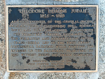
Theodore Dehone Judah
1826-1863
As Chief Engineer of the Central Pacific Railroad, Judah’s engineering skill, political savvy and financial genius, along with the promoters’ capital, culminated in formation and construction of the Trans-Sierra leg of the first transcontinental railroad. While fighting the excesses of the railroad’s promoters, he died without seeing his dream completed.
Dedicated August 14, 1982
Chief Truckee Chapter No. 3691
E Clampus VitusLocation. 39° 19.648′ N, 120° 11.123′ W. Marker is in Truckee, California, in Nevada County. Marker can be reached from Donner Pass Road. Marker is located at the back of the Truckee Railroad Depot across from the railroad tracks. Touch for map. Marker is at or near this postal address: 10158 Donner Pass Road, Truckee CA 96161
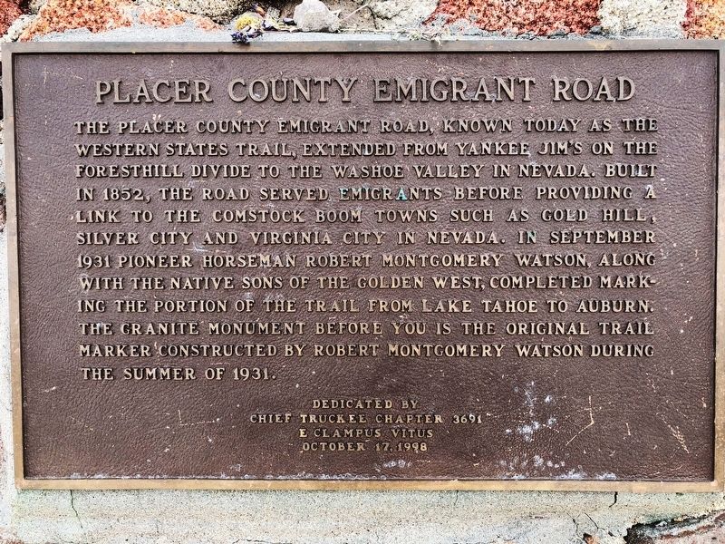
Placer County Emigrant Road
The Placer County Emigrant Road, known today as the Western States Trail, extended from Yankee Jim’s on the Foresthill Divide to the Washoe Valley in Nevada. Built in 1852, the road served emigrants before providing a link to the Comstock boom towns such as Gold Hill, Silver City and Virginia City in Nevada. In September, 1931, pioneer horseman Robert Montgomery Watson, along with the Native Sons of the Golden West, completed marking the portion of the trail from Lake Tahoe to Auburn. The granite monument before you is the original trail marker constructed by Robert Montgomery Watson during the summer of 1931.
Dedicated August , 1998 by E Clampus Vitus, Chief Truckee Chapter 3691.
39° 11.399′ N, 120° 16.531′ W. Marker is near Tahoe City, California, in Placer County. West side of Squaw Valley Ski Resort on the edge of Granite Chief Wilderness.
Olympic Valley CA 96146, United States of America.
Regarding Placer County Emigrant Road.
Robert M. Watson: Tahoe City Lawman
By Mark McLaughlin – May 24, 2017 https://thetahoeweekly.com/2017/05/33548/
In 1930, less than two years before he died, Watson constructed a granite monument near Emigrant Pass, a piece of history that still stands. Incredibly, Watson’s homemade commemorative marker, dedicated “to pioneers and men who served their country in wars and settling the country” at an elevation of 8,774 feet has withstood 87 winters at the top of Squaw Valley. Today, the Emigrant Road is now part of the 100-mile Western States Trail Race, an internationally renowned ultra-marathon endurance race for equestrians and runners.
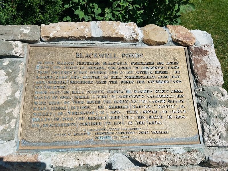
Blackwell Ponds
In 1902 Marion Jefferson Blackwell purchased 360 acres from the State of Nevada, 556 acres of adjoining land from Sweeney’s Hot Springs and a lot with a house. He raised carp and catfish to sell commercially also hay and horses. Neighbors used the ponds for swimming and ice skating.
Born 1847, in Hall County, Georgia he married Nancy Amna Mayes in 1866. While living in Jamestown, California his wife died. He then moved the family to the Carson Valley near Genoa in 1895. He married Martha “Mattie” H. Willey in Yerington in 1899, then moved to Eagle Valley in 1902. He resided here till his death in 1914. His descendants continue to live in the area.
E Clampus Vitus Chapters
Julia C. Bulette – Snowshoe Thompson – Chief Truckee
October 12, 2001
Erected 2001 by E Clampus Vitus Chapters Julia C, Bulette, Snowshoe Thompson, Chief Truckee.
Location. 39° 10.896′ N, 119° 44.848′ W. Marker is in Carson City, Nevada. Marker is on Spooner Drive near Windridge Drive, on the right when traveling west. Touch for map. Marker is in this post office area: Carson City NV 89706
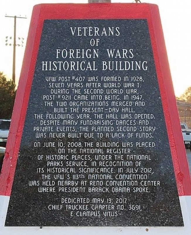
Veterans of Foreign Wars Historical Building
VFW Post #207 was formed in 1926, seven years after World War I. During the Second War, Post #9211 came into being. In 1945, the two organizations merged and built the present-day hall which opened the following year.
Despite many fundraising dances and private events, a planned second story was never built due to lack of funds.
On June 10, 2008, the building was placed on the National Register of Historic Places, under the National Park Service, in recognition of its historical significance. In July 2012, the VFW’s 113th National Convention was held nearby at Reno Convention Center where President Barack Obama spoke.
Erected 2017 by Chief Truckee Chapter No 3691, E Clampus Vitus.
Location. 39° 29.358′ N, 119° 47.971′ W. Marker is in Reno, Nevada, in Washoe County. Marker is on VFW Historic Lane near Baker Lane, on the right
Marker is on the base of the flag pole. 255 VFW Historic Lane, Reno NV 89509
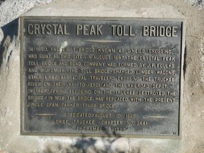
Crystal Peak Toll Bridge
In 1860, the first bridge, known as O’Neils Crossing, was built at this site. In August 1867, the Crystal Peak Toll Bridge and Road Company was formed by J.P. Foulks and M.J. Smith. The toll bridge charged lumber wagons, stage lines and local travelers crossing the Truckee River on their way to Verdi and the railroad depot. In 1906, spring flooding on the Truckee destroyed the bridge. In 1928, the bridge was replaced with the present single span Parker truss bridge.
Erected 1985 by E Clampus Vitus, Chief Truckee Chapter No. 3691.
Location. 39° 31.453′ N, 119° 59.629′ W. Marker is in Verdi, Nevada, in Washoe County. Marker is on Bridge Street west of Lakeview Drive, on the right when traveling north.
449 Bridge Street, Verdi NV 89439 Touch for map.
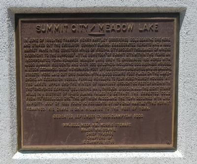
Summit City / Meadow Lake
In June of 1863, the trapper Henry Hartley discovered gold bearing ore here and staked out the Excelsior Company claims. Exaggerated reports and a 1865 market panic in the Comstock mines of Virginia City brought thousands of miners overnight to the supposed “Little Comstock” of Summit City. Within two years an incorporated town, renamed Meadow Lake, grew to encompass 160 acres with 4,000 summer residents and over 500 buildings, including 200 business houses, a stock exchange, daily newspaper, post office, school, breweries and 80 saloons. Streets were laid out grid fashion, with a 8,000 square foot plaza on the lakeshore. An excursion vessel, ferried revelers to four hurdy-gurdy houses at the lake’s upper end. The winter of 1866-1867 brought 30 feet of snow with the “snowshoe express” delivering mail through Cisco. In all, eight stamp mills in a district of 10,910 claims failed to extract the expected gold from its “rebellious ore.” The optimism faded, and the town declined with like rapidity. July of 1869 found 80 residents. By 1873 only Hartley “The Hermit” remained. His grave is on a hillside to the west of town.
Erected 1995 by E Clampus Vitus, Wm Bull Meek – Wm Moris Stewart Chapter 10, Major Wm. Downie Chapter 1849 & Chief Truckee Chapter 3691.
Location. 39° 24.577′ N, 120° 30.188′ W. Marker is near Soda Springs, California, in Nevada County. Marker is on Tahoe National Forest Service Road 843, on the left when traveling south. Marker is in this post office area: Soda Springs CA 95728, Touch for map.
America’s First Transcontinental Highway
The Lincoln Highway was conceived and promoted by industrialists who were determined to act on the concept of creating one transcontinental highway from amongst the various and fragmented paths, trails and city streets. The LH (1913 -1927) brought notoriety and some prosperity to rural Nevada towns along its path.
Farm District Road from Fernley toward Hazen was incorporated into the Lincoln Highway. The LH served until the Federal Highway System was developed and continued to be promoted by the towns along its route through the 1930’s. Dedicated May 11, 2002 Nevada-Sierra Chapter, Lincoln Highway Association Chief Truckee, Snowshoe Thompson & Julia C. Bulette Chpts. E Clampus Vitus Fernley Preservation Society
Erected 2002 by Nevada-Sierra Chapter, Lincoln Highway Association, Julia C. Bulette Chapter E Clampus Vitus and Fernley Preservation Society.
39° 35.556′ N, 119° 13.611′ W. Marker is near Fernley, Nevada, in Lyon County. Marker is on Farm District Road 0.6 miles south of Farm District Road (Alternate U.S. 50), on the left when traveling south. Immediately east of the Cottonwood Elementary School driveway
924 Farm District Rd, Fernley NV 89408, United States of America. Touch for map